St Cuthbert's Way
|
This is a brief description of St Cuthbert's Way undertaken in early
August 2000. The weather varied from sunny to wet but was never cold.
The paths were in good condition and the Way was very well marked
requiring only an occasional reference to a map. In built up areas
the Way is marked with signs, usually attached to lamp posts. In open
country the Way is marked with arrows and the St Cuthbert's cross
logo, attached to posts, gates or styles.
|
|
Clicking
on photogaphs will load a larger version, in a new window
|
Further information about the walk can be obtained by contacting the following.
MILEAGE
CHART (Not including detours to accommodation, places of interest etc.)
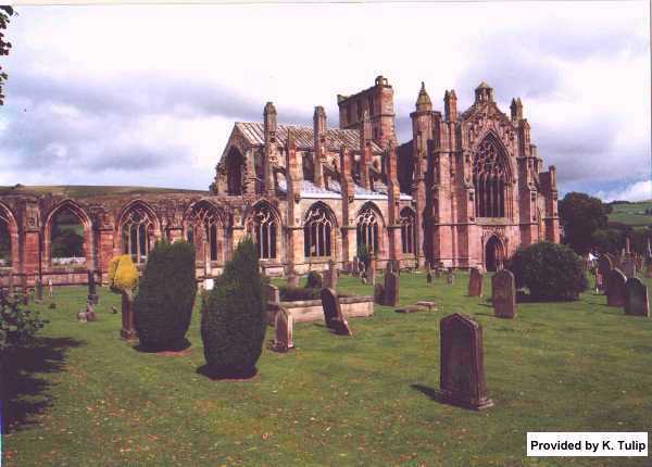
MELROSE TO ST BOSWELLS (7.25 miles)
|
Starting from Melrose Abbey walk south through the market square and
continue under the underpass. After about 100 yards turn left between
some houses and follow the path through some trees to wooden steps which
take you out of the built up area. The path climbs through some fields
and onto the open moor and between two of the Eildon hills to a height
of about 1400 feet (430 metres), giving good views of Melrose behind and
the surrounding area.
|
Melrose
Abbey
|
 |
The Way then drops down through woodland and passes through the village of
Bowden. There is a section just after Bowden, where the path follows the Bowden
Burn, according to the official maps dogs are not permitted on this section,
although we had our dog and met some local people with their dogs. After this
section there is about a mile on the road before the Way passes through the
edge of Newtown St Boswells. Leaving the village the Way follows the edge of
a stream to meet, and follow the banks, of the river Tweed. You will pass the
Drybrough footbridge over the Tweed, which if time allows, can be crossed to
the village of Dryburgh. A visit to Dryburgh Abbey will cost £2.50 (in
2000) or you can climb the hill out of the village to visit the sandstone statue
of William Wallace. Continuing to follow the Way along the river bank will bring
you into the village of St Boswells.
The Way travels along part of the main street of St Boswells before climbing
up behind the village, to the golf course. St Boswells has a hotel, The Buccleugh
Arms, some shops and accommodation is available.
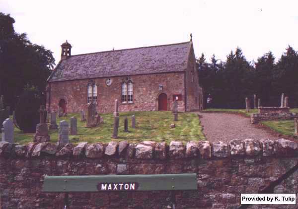
ST BOSWELL TO JEDBURGH (12.75 miles)
|
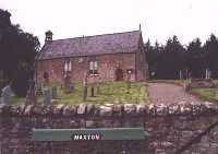
Maxton
Kirk
|
On leaving the village of St Boswells you go past the club house and
across the golf course, the path again joins and follows the banks of
the Tweed, on a very interesting part of the walk. You will pass the Mertoun
Mill and Mertoun Bridge. After some open pasture and woodland the Way
eventually climbs up steps from the river to bring you out in front of
the pretty Maxton Kirk and then takes you on into the village of Maxton.
|
|
After Maxton the Way follows country lanes for about 1 - 1.5 miles before joining
Dere Street, a few yards before the A68 road. At this point Dere Street, which
originally ran from York to the Forth and is marked with a Roman helmet rather
than the usual St Cuthbert's cross, runs roughly parallel to the A68. The Way
follows Dere Street for 5 - 6 miles.
|
As the St Cuthbert's Way takes you down Dere Street you will pass some
interesting features that you may wish to digress to. First feature, very
close to the Dere Street, over a style, is Lilliards stone.
Lady Lilliard fought at the battle of Ancrum Moor in 1545.
|
|
|
Inscription
on Lilliard's Stone
|
Fair
Maiden Lilliard lies under this stane
Little was her stature, but muckle was her fame
Upon the English loons she laid many thumps,
And when her legs were cuttit off, she fought upon her stumps. |
|
Further along the Dere Street, on the top of a hill to the left and some distance
from Dere Street, is the Waterloo Monument. This has a viewing platform around
the top.
You can also leave Dere Street and St Cuthbert's Way to visit Harestanes Visitors
Centre, which is open between April and October and is about half a mile to
the right of the Street. This gives access to toilets and refreshments and accommodation
in the nearby village of Ancrum. There is also a bus service from Harestanes
to Jedburgh.
After Harestanes, Dere Street passes through some woodland, part of the Monteviot
estate, and across a long swaying suspension bridge over the Teviot. Continuing
along Dere Street you will pass by Jedburgh. If you want to stop off in Jedburgh
there are several roads that cut across Dere Street that can be followed into
the town. The easiest route to follow is the first road, the A698, which you
cross at Jedfoot bridge. This route into Jedburgh is flat and is about 2 - 2.5
miles long. Jedburgh has a wide range of facilities to offer.
JEDBURGH TO TOWN YETHOLM (14 miles)
After Jedburgh, the Way continues along Dere Street for a while before leaving
it to follow the road to Crailinghall. The Way then follows some farm tracks,
crosses Cessford Moor and then some country road to eventually bringing you
to the farm of Cessford and the ruins of Cessford Castle. Continuing on more
roads the Way takes you into the village of Morebattle. The pub was recently
closed down and apart from a small shop it offered very little in the way of
mid day refreshments.
|
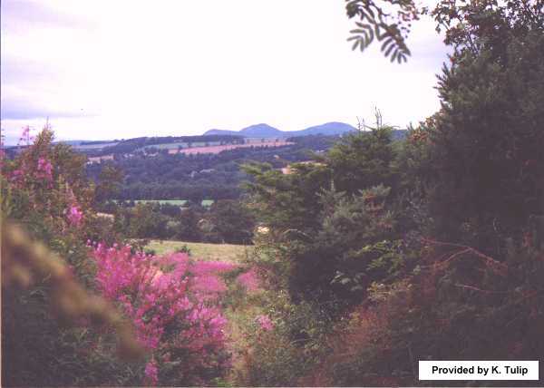
After Morebattle the Way follows the road and climbs before dropping
back into the Kale Water valley bottom. Eventually you will leave the
road and cross the only bridge, over the Kale Water, specifically built
to join up the route of St Cuthbert's Way, and climb up towards Grubbit
Law, and on to the top of Wideopen Hill.
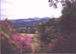
On a clear day this will give some beautiful views back to the Eildon
hills and also of Cheviot. You will pass the half way marker for St Cuthbert's
Way before dropping down into the Bowmont Valley, onto the road, about
1 mile out of Town Yetholm.
|
Looking back on the Eildon Hills
|
 |
Just before entering the village the Way diverts and follows a stream just
south of the village. You will need to leave the path to enter the village,
where there is a pub, local shops and accommodation.
TOWN YETHOLM TO WOOLER (12 miles)
The Way leaves Town Yetholmand follows the road to the smaller village of Kirk
Yetholm. For a short while you will walk on the final section of the Pennine
Way. Soon after climbing out of Kirk Yetholm you leave the road to climb over
a series of hills and through some dense woodland, past the Border fence marking
the passing into England, until you reach the farm of Elsdonburn. The Way continues
down the farm road and along the valley bottom, passing the entrance to Hethpool
House and past some pretty farm cottages.
You then cross the College Burn and climb through some woodland and into the
hills between Yeavering Bell and Easter Tor, which on a clear day gives some
excellent views to the north. The Way then crossed the open moor of Wooler Common
and also some woodland, before dropping down into Wooler town, which has a wide
range of facilities.
WOOLER TO HOLY ISLAND (17 miles)
From Wooler the Way climbs onto Weetwood Moor before dropping back down to
the road again to cross the Weetwood bridge. After some roadwork passing through
some large farms the Way follows a series of tracks into the St Cuthbert's Cave
woods. A short detour takes the Way to St Cuthbert's cave. On leaving the wood
you will cross some open moor, which on a clear day should give you your first
glimpse of Holy Island. The Way then passes into Shiellow wood, followed by
a short piece of roadway before arriving at the village of Fenwick. On leaving
Fenwick you will soon cross the A1 road and then after following a track for
a while the main east coast railway line.
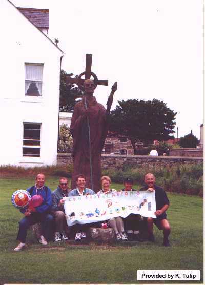
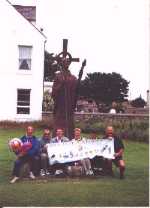
|
Journeys
end - St Cuthbert's Statue, Holy Island
|
Two more fields will bring you to the shore line and then turn left,
for about a quarter of a mile, to reach the causeway. The causeway is
closed by the incoming tide, for about 5 in every 12 hours. It is essential
to time your walk to give you a reasonable window of opportunity to cross.
There is an alternative to the causeway, called the Pilgrims Way, which
cuts across the sand to the right of the causeway, and is about 1 mile
shorter.
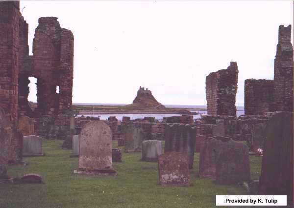
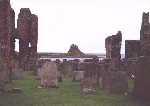
|
Lindesfarne
Priory and Castle
|
 |
 |
It is marked by a line of poles across the sand, but the window of opportuity
for crossing is even smaller than it is for the causeway. After crossing the
causeway there is about 1.5 miles on the shore of Holy Island, before reaching
the Lindesfarne Priory, where St Cuthbert's Way finishes.
Details of Holy Island crossing time can be found here.
|
|
TEL No
|
OTHER INFO
|
|
Tourist Information Centre, Abbey House, Melrose.
|
01896 - 822555
|
|
|
Scottish Borders Tourist Board, Tourist Information Centre, Murray's
Green, Jedburgh. TD8 6BE
|
01835 - 863435
|
info@scot-borders.co.uk
http://www.scots-borders.co.uk
|
|
Harestanes Countryside Visitors Centre, Ancrum, Jedburgh. TD8 6UQ
|
01835 - 830306
|
|
|
Tourist Information Centre, 16 Market Place, Wooler.
|
01668 - 282123
|
|